What to see
How to explore the park
The Lanín National Park is huge and therefore, the best way to discover it is to choose one area and explore it. The northern area is known for its monkey puzzle trees or pehuen tree forests, where you can discover the culture and traditions of the Mapuche community. The central area is the doorway to the impressive Lanín Volcano; and in the south, San Martín de los Andes offers a great variety of activities and it is the starting point of the Route of the Seven Lakes.
There are several roads and a large network of trails that you can explore on foot, by bike or by car. The legendary Route 40 passes through this area allowing you to stop by some of the main cities.
FROM SAN MARTÍN DE LOS ANDES

On the shore of the Lácar Lake, this city is the doorway to the southern area of the Lanín National Park. In spring and summer, you can do different activities, and in winter, it becomes one of the main snow destinations, with its ski resort in Chapelco Mountain.
San Martín is where the famous Route of the Seven Lakes starts, connecting San Martín with Villa La Angostura, along lakes and spectacular landscapes.
To the north: lakes, mountains and hot springs

Around the Lácar Lake, you can enjoy the beaches and camping sites, bike around lakes and mountains or go trekking around the Lácar Lake, a hike that requires camping for 2 or 3 nights.
Along Provincial Route 62, you can visit lakes and ponds, hot springs and the Carirriñe border crossing to Chile. A beautiful scenic route to drive along on off-road vehicles or trucks with high ground clearance.
Following Provincial Route 48, you can visit the Yuco Beach, camp out in Nonthué and climb Malo Mountain, and if you continue up to the border with Chile, you will reach the Hua Hum border crossing, where you can visit the Queñi Lake and its hot springs. The trail to climb the Colorado Mountain is a half-day hike.
To the south: beaches and lakes

Catritre and Quila Quina are two beautiful beaches to enjoy the summer, practice windsurfing, kitesurfing and other activities. You can take a sailing tour to Quila Quina from San Martín de los Andes or you can travel by car along a steep paved and gravel road. Trekking enthusiasts can reach this beach by following a trail that completely surrounds the Lácar Lake, and which requires 2 or 3 nights camping out.
The Hermoso Lake, near San Martín, is the highlight of the area, with cottages, refuges and camping sites. If you take a diversion from Provincial Route 63, you will discover the Meliquina Lake and the town of the same name.
Trekking and mountain biking

From San Martín, you can also go trekking or mountain biking to the Rosales Lake, the Trompul Rock and the Colorado, Chapelco and Curruhuinca Mountains. You can reach the summit of the Colorado, Malo, Chapelco, Aseret, Huanquihue, Acol and Mesa Mountains by car.
Off-road trip
Drive north following Provincial Route 62 to visit the Lolog Lake, which offers a wide range of services and accommodation. If you follow along this route, you will arrive at the small Verde Lake, located between the Curruhué and Epulafquen Lakes. This is the base to climb the Achen Ñiyen Volcano. There is a trail bordering the Lolog Lake all the way to the Lácar Lake, which is great to go trekking for several days.
After the Epulafquen Lake, you will find the Lahuen Co hot springs and the border crossing Carirriñe to Chile. It is a very nice route to drive along on off-road vehicles or trucks with high ground clearance.
http://neuquentur.gob.ar/es/destinos/san-martin-de-los-andes/
http://neuquentur.gob.ar/es/destinos/ruta-de-los-7-lagos/
FROM JUNÍN DE LOS ANDES

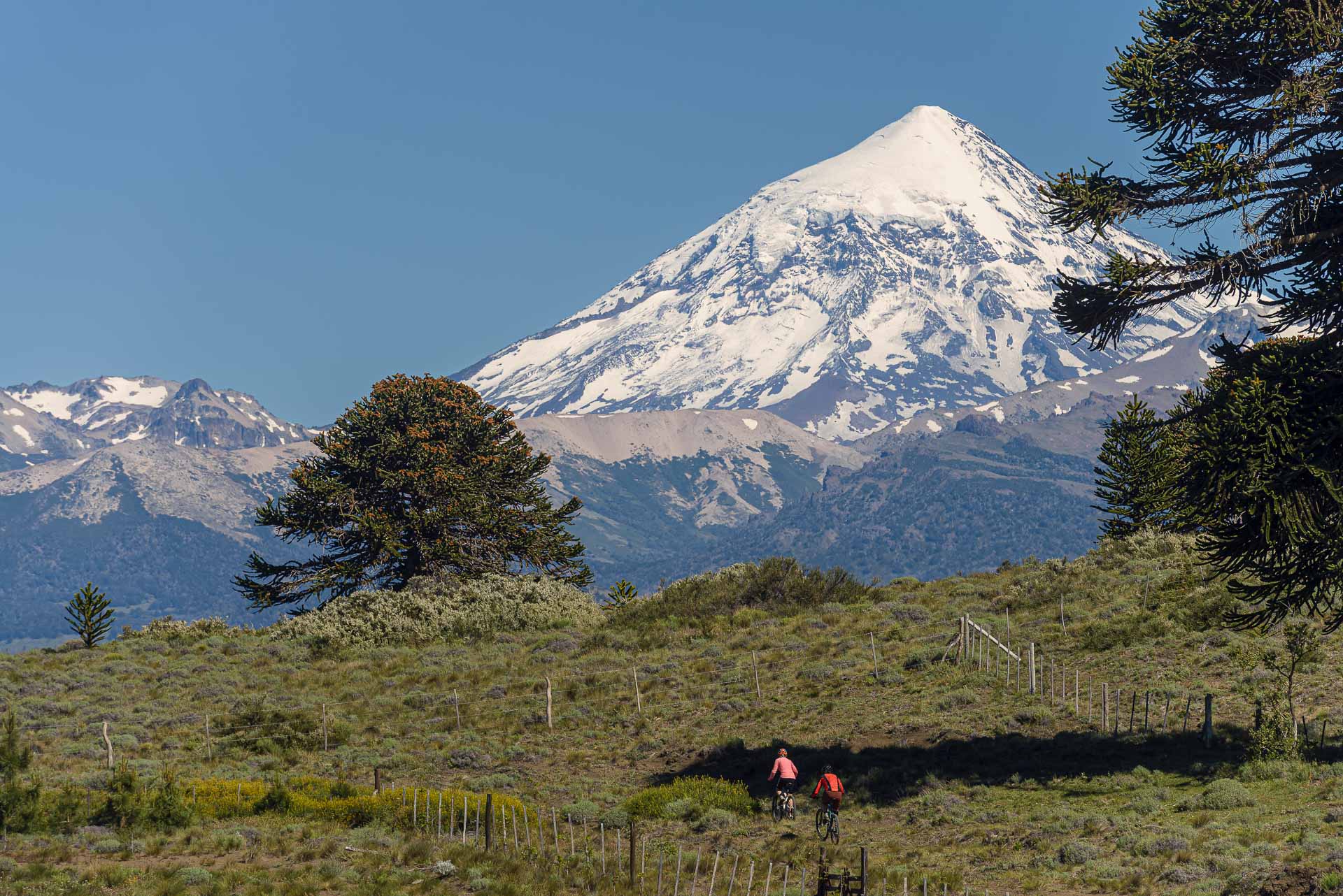
Located in the central area of the Lanín National Park, Junín de los Andes is the doorway to the impressive Lanín Volcano and its surroundings.
Provincial Route 60

Provincial Route 60 takes you close to the northern side of the Lanín Volcano through a paved road surrounded by forests of monkey puzzle trees. Located 65 km away from Junín de los Andes, Río Turbio Park Ranger Station (with a camping site and services) is the starting point of the trail to climb up the volcano (3776 MSL).
You can climb up to the refuges (medium to high difficulty), stay overnight and return the following day, or you can climb to the summit (this a two-day hike with an overnight stay in a refuge accompanied by a certified guide). In both cases, you need to contact the refuge beforehand to book your stay. For more information and online registration, please visit https://www.pnlanin.org/circuitovolcanlanin
Following Provincial Route 60 and 3 km away from the Park Ranger Station, you will find the border crossing Tromen/Mamuil Malal connecting the Villarrica National Park to the other side of the border.
Provincial Route 61

Provincial Route 61 runs along the Huechulafquen and Paimún Lakes. The Huechulafquen Lake is one of the largest lakes in the park offering several camping sites where you can also spend the day. There are many trails that go deep into the forest and close to the slopes of the Lanín Volcano. Sailing tours depart from Canoas Port to the Paimún and Epulafquen Lakes, where you can also visit the "dwarf forest."
http://neuquentur.gob.ar/es/destinos/junin-de-los-andes
FROM ALUMINÉ

In the northern area of the park, monkey puzzle trees or pehuen forests (ancient trees considered sacred by the Mapuches) create one of the most incredible views in Patagonia.
Pehuén Route

The highlights of this area are the Ñorquinco, Ruca Choroi and Quillén Lakes. It is a great place to go hiking, trekking, horseback riding and kayaking, or just simply enjoy the lakes and beaches. This area is part of the Pehuén Route, a provincial circuit with breathtaking scenery extending far beyond the national park.
The Aluminé River is one of the best rafting and kayaking destinations in the world, with several specialised service providers that will help you embark on this adventure.
The Ñorquinco Lake has several camping sites and cottages, with trails to go hiking or biking. For trekking enthusiasts, there is a trail (part of the Huella Andina trail) connecting the Ñorquinco Lake with the Ruca Choroi Lake, with camping sites, but no services.
Pulmarí Scenic Route

The route leading to the lake, known as the Pulmarí Scenic Route, is an attraction in itself and it also connects the Moquehue and Aluminé Lakes. It is a gravel road much sought after by bikers. Several camping sites and services are managed by Mapuche communities that are open to visitors who are eager to know their culture linked to the pehuen tree and the pine nut harvest (an ancient seed considered sacred).
Lakes and farms

Other 2 gravel routes lead to the Ruca Choroi and Quillén Lakes, and are great to enjoy the view and relax. The farms in the area offer horseback riding and sport fishing tours, and some of them also include accommodation. There are camping sites on the shores of both lakes.
To visit the area, you can depart from Aluminé (60 km of gravel road) or spend some nights in a cottage or camping site on the shore of the Ñorquinco, Pulmarí or Quillén Lakes.
Tour around Chile
To the north of Villa Pehuenia, outside the National Park, you will find the Pino Hachado international border crossing to continue your trip to Chile and visit the Conguillio National Park and other neighbouring protected areas. Finally, you can return back to Lanín National Park through the Tromen border crossing.
http://neuquentur.gob.ar/es/destinos/alumine/


